Visayas
| Native name: Kabisay-an | |
|---|---|
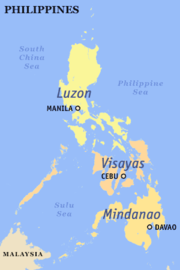
 Map of the Philippines; the center shows the location of the Visayas |
|
| Geography | |
| Location | South East Asia |
| Archipelago | Philippines |
| Major islands | Bohol, Cebu, Leyte, Masbate, Negros, Panay, Samar and Palawan. |
| Area | 61,077 km2 (23,582 sq mi) |
| Highest elevation | 2,435 metres / 7,989 ft |
| Highest point | Kanlaon |
| Country | |
|
Philippines
|
|
| Regions | Central Visayas, Eastern Visayas and Western Visayas. |
| Largest city | Puerto Princesa City |
| Demographics | |
| Population | 17,155,207 (as of 2007 Philippines census) |
| Density | 294.28 |
| Ethnic groups |
Visayans (Aklanon, Boholano/Bol-anon, Caluyanon, Capiznon, Cebuano, Eskaya, Hiligaynon, Karay-a, Masbateño, Porohanon, Romblomanon, Waray), Ati and other ethnic groups. |
The Visayas is one of the three principal geographical divisions of the Philippines, along with Mindanao and Luzon. It consists of several islands, primarily surrounding the Visayan Sea. Its population are referred to as the Visayans.
The major islands of the Visayas are Panay, Negros, Cebu, Bohol, Leyte, Samar and Palawan. The region may also include the islands of Romblon and Masbate, whose population identify as Visayan.
Contents |
History
The early people in the Visayas region were Austronesians and Negritos who migrated to the islands about 6,000 to 30,000 years ago. These early settlers were animist tribal groups. In the 12th century, settlers from the collapsing empires of Srivijaya, Majapahit and Brunei, led by the chieftain Datu Puti and his tribes, settled in the island of Panay and its surrounding islands. By the 14th century, Arab traders and their followers, venturing into the Malay Archipelago, converted some of these tribal groups into Muslims. These tribes practiced a mixture of Islam and Animism beliefs. There is also some evidence of trade among other Asian people. The Visayans were thought to have kept close diplomatic relations with Malaysia and Indonesian kingdoms since the tribal groups of Cebu were able to converse with Enrique of Malacca using the Malay language when the Portuguese explorer Ferdinand Magellan arrived in 1521.
After the Magellan expedition, King Philip II of Spain sent Ruy López de Villalobos and Miguel López de Legazpi in 1543 and 1565 and claimed the islands for Spain. The Visayas region and many tribes began converting to Christianity and adopting western culture. By the 18th and 19th centuries, the effects of colonization on various ethnic groups soon turned sour and revolutions such as those of Francisco Dagohoy began to emerge.
During the Philippine Revolution and the Philippine–American War between 1896 to 1913, the island of Negros and other neighboring islands initiated their revolution. After gaining Philippine independence from colonial rule following World War II in 1946, the Visayas region established its community and re-formed its government, producing several notable presidents coming from the Visayas region.
In 2005, the island of Palawan was transferred to Region VI (Western Visayas) by Executive Order 429.[1] However this planned reorganization was held in abeyance.[2] Hence, Palawan currently remains (as of May 2007) part of Region IV-B.
Administrative divisions
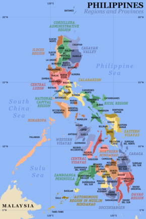
Administratively, the Visayas is divided into 3 regions, namely Western Visayas, Central Visayas and Eastern Visayas. Each region is headed by a Regional Director who is elected from a pool of governors from the different provinces in each region.
The Visayas is composed of 16 provinces, each headed by a Governor. A governor is elected by popular vote and can serve a maximum of three terms consisting of three years each.
As for representation in the Philippine Congress, the Visayas is represented by 44 Congressmen elected in the same manner as the governors.
Western Visayas (Region VI)
Western Visayas consists of the islands of Palawan, Panay and the western half of Negros. The regional center is Iloilo City. Its provinces are:
Central Visayas (Region VII)
Central Visayas includes the islands of Cebu and Bohol and the eastern half of Negros. The regional center is Cebu City. Its provinces are:
Eastern Visayas (Region VIII)
Eastern Visayas consists of the islands of Leyte and Samar. The regional center is Tacloban City. Its provinces are:
Culture
Legends
Historical documents written in 1907 by Visayan historian Pedro Alcántara Monteclaro in his book Maragtas tell the story of the ten chiefs (Datus) who escaped from the tyranny of Datu Makatunaw from Borneo and came to the islands of Panay. The chiefs and followers were said to be the ancestors of the Visayan people.
The documents were accepted by Filipino historians and found their way into the history of the Philippines. As a result, the arrival of Bornean tribal groups in the Visayas is celebrated in the festivals of the Ati-Atihan in Kalibo, Aklan and Binirayan in San José, Antique.
Foreign historians such as William Scott conclusively proved the book to be a Visayan folk tradition.[3] Panay boasts of the Hinilawod as its oldest and longest epic.
Hypotheses
A contemporary theory based on a study of genetic markers in present-day populations that Austronesian people from Taiwan populated the region of Luzon and headed south to the Visayas, Borneo, Indonesia, then to Pacific islands and to the east of the Indian Ocean.[4] The study, though, may not explain inter-island migrations, which are also possible, such as the Tagalog migration to Luzon.
According to Visayan folk traditions, the Visayas were populated by Malays migrating from Borneo to Mindanao and to the Visayas, while other Malays crossed to Palawan through Sabah. Other Malays were suggested to have crossed from Samar island to the Bicol region in Luzon. The theory suggests that those ancient tribal groups who passed through Palawan may have migrated to what is now the island of Luzon.
A supplementary theory was that at that period, the Malay people were moving north from Mindanao to the Visayas and to Luzon. Various groups of Europeans and Chinese also integrated with the native population during that period.
See also
Notes
- ↑ President of the Philippines. "Executive order No. 429". Office of the Press Secretary. http://www.ops.gov.ph/records/eo_no429.htm. Retrieved 2007-05-18.
- ↑ President of the Philippines (August 19, 2005). "Administrative Order No. 129". Office of the Press Secretary. http://www.ops.gov.ph/records/ao_no129.htm.
- ↑ Scott 1984, pp. 81-103.
- ↑ Cristian Capelli et al. (2001). "A Predominantly Indigenous Paternal Heritage for the Austronesian-Speaking Peoples of Insular Southeast Asia and Oceania" (PDF). American Journal of Human Genetics 68: 432–443. doi:10.1086/318205. http://hpgl.stanford.edu/publications/AJHG_2001_v68_p432.pdf.
References
- Scott, William Henry (1984), Prehispanic Source Materials for the study of Philippine History, New Day Publishers, ISBN 971-10-0226-4.
